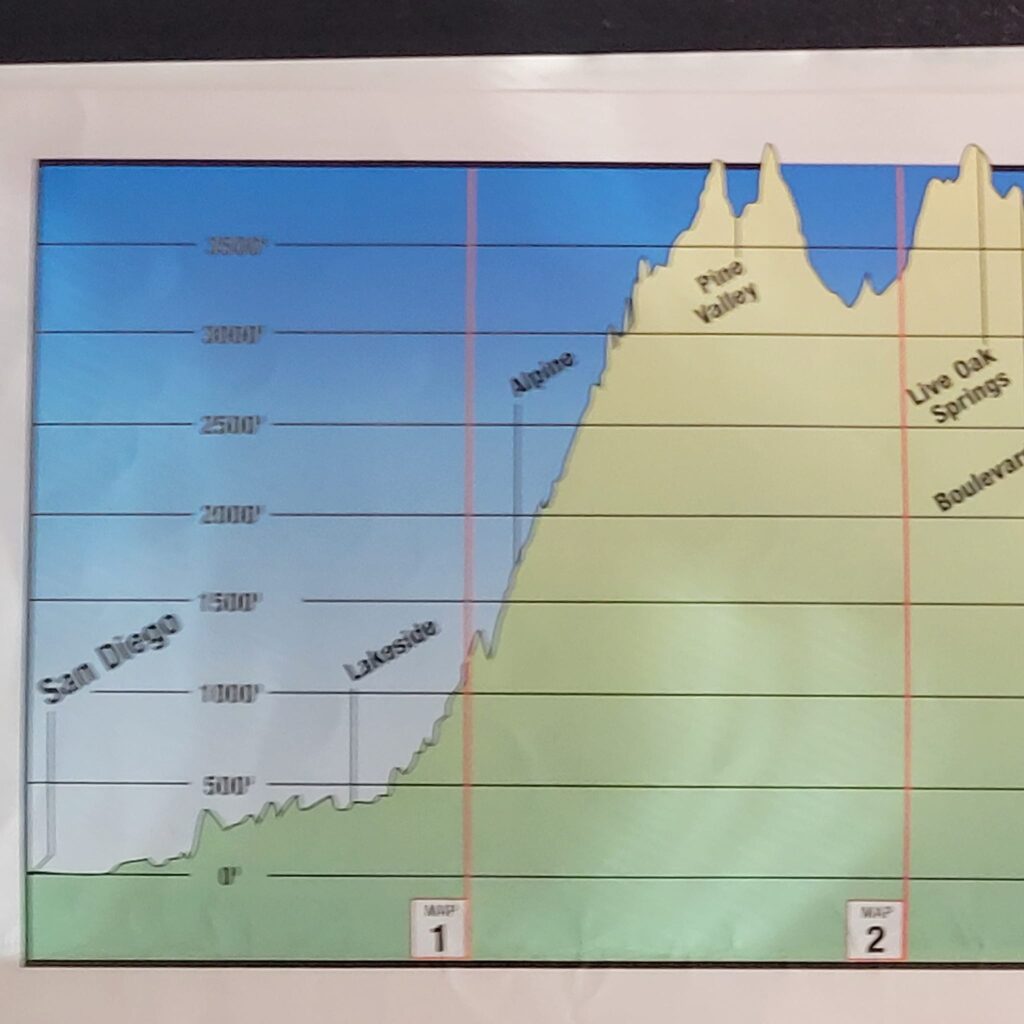
The Pacific Ocean at San Diego, CA to Santee, CA
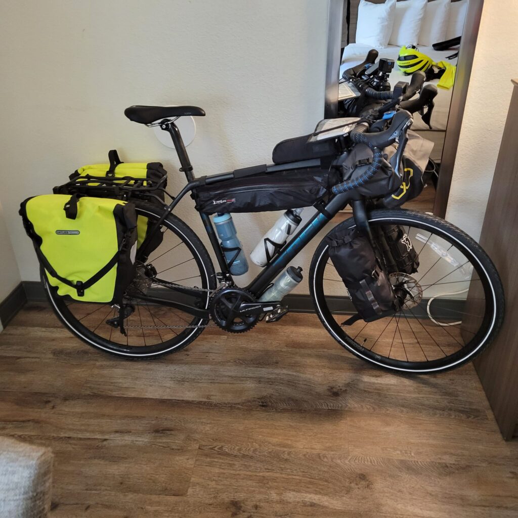
Thursday, March 23rd, departure day for both Jenny and myself. And we’re off to a rough start. Jenny’s cab to the airport doesn’t show up so we are forced to ask the hotel desk for help in finding us a new cab. Fortunately, the replacement cab shows up and delivers Jenney to the airport with time to spare. And I am now by myself and finalizing my packing of the bike for the journey that lies ahead. I’m nervous, anxious, scared, and actually feeling sick to my stomach. Despite everything, I somehow manage to get everything together and I am now set to ride out to my starting point: the western terminus of the Adventure Cycling Association’s Southern Tier Bicycle Route. It’s about a five-mile ride from our hotel situated in the Old Town District of San Diego to the beginning of the route. I’m confused by my Garmin device and the navigation app on my smart phone and get lost a couple of times. Eventually, I figure it out and I am headed westbound on the San Diego Bicycle Trail towards the Pacific Ocean. Within a half hour I arrive at the Pacific Ocean where I stop for several minutes just to shoot some video and take some pictures. The skies are partly cloudy and the temperatures are cool but comfortable, requiring only a light jacket. A couple of people at the beach stop and inquiry about my journey; they seem incredulous when I explain what I’m about to embark on and my final destination. In fact, at this point, I’m more than a little disbelieving myself. My bike is now heavier than anything I’ve ever ridden and I am so anxious of what lies ahead. I feel lonely, lost, and afraid. Nothing like the adventurer I’ve always dreamed about. But despite my reservations, I hop on my heavy-laden bicycle and start pedaling eastward, towards St. Augustine, Florida; and a goal to travel a distance that I have no ability to even comprehend at this point in time.
One thing that strikes me right away and something that I will encounter at every major population center along the route are the number of homeless people encamped alongside the trail. None of them were ever threatening in any way, but, nonetheless, it made me uneasy.
Navigating my way eastward through San Diego is frustrating. My first day trying to use my Garmin device and my smart phone app for navigation is difficult and at times problematic for me, but I am generally staying on course. There definitely is a learning curve here. I get off route a few times but manage to get back on route and eventually I start to become more comfortable using these high-tech devices for navigation. Eventually the Adventure Cycling Association’s GPX files that I uploaded onto my Garmin Edge 530 and the smart phone app that I also purchased from the Adventure Cycling Association would prove to be the perfect combo for navigating the entire Southern Tier route all the way across the continent. I also utilized their paper maps and Google Maps as well, but I mostly used those for locating services such as hotels, restaurants and grocery stores. But when I was on my bike, my Garmin device and the smart phone navigation app were all I ever really needed.
Although much of the route through San Diego is on dedicated bicycle trails, enough of it is on busy city streets that it is starting to frazzle my nerves. In addition, I am still learning how to use my navigation tools and frequently find myself off route. But I quickly correct my mistakes. Eventually, after a few hours and much to my relief, the route offers a reprieve from busy traffic and turns into Mission Trails Regional Park. Here vehicular traffic is forbidden and the towering hills and rock outcroppings are stunning. At the visitor’s center I take a break, rest, and grab a snack. The next few miles make for delightful cycling as there are no cars, only hikers and other cyclists, and the views are spectacular. Now this is what I signed up for when I first contemplated this adventure. However, very shortly, I am back on busy streets. But it is now late afternoon and my destination for the night, the town of Santee, is not far away. The first hotel I check is already full. I proceed to my second choice hoping desperately that there would be space there. Otherwise, I face the prospect of several more miles of cycling to find either a hotel or proper camping spot for the night. Fortunately, the Best Western Inn of Santee has a room. And as a bonus, there is a nice Mexican restaurant just down the street where I am able to procure a veggie burrito. The lesson I learned is, that although any long-term planning is impossible on this journey, it might be best to always have a reservation at either a hotel or a campsite at least one or two days in advance. Day one is now in the bag. And I am feeling a little more relaxed. After I get back from dinner, I give Jenny a call and talk with her for several minutes. Jenny proves to be my link to the real world and my sounding board for the duration of this journey, without the phone calls home to her, I don’t know if I would have made it. I get ready for bed, but I’m still a little unsettled because I know the next couple of days will feature some particularly grueling climbs. But I’ll worry about that tomorrow morning. Right now, I need a good night’s rest. Day one on the Southern Tier: 5 miles just to get to the start of the route from the hotel where we stayed while in San Diego, and another 22.3 miles (35.9k) from the start of the route at the Pacific Ocean to my hotel in Santee. Total elevation gain is around 1,200 feet (365m).
Day 2 overall on the Southern Tier – Day 2 of actual riding – Friday, March 24th, 2023 – Santee, CA to Alpine, CA
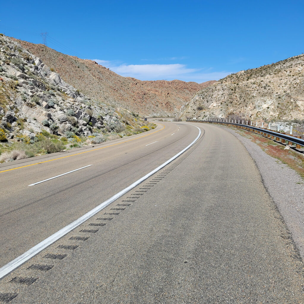
Starting the day in Santee, it still seems as though I am on the eastern fringes of the San Diego area. But after a couple of hours the landscape opens up and gives way to a more rural setting. The roads generally are in decent shape and the shoulders are plenty wide to accommodate cyclists. However, it is a steady climb much of the way to the town of Alpine, my destination for the day, with a constant 4-5 percent grade; just enough to feel a strain and discomfort in the legs.
About midway through my day, I meet a couple of other cyclists headed westbound. We stop and chat for several minutes and compare notes about our journeys so far. I warn them about negotiating heavy traffic at times in San Diego. This encounter is something that I wish had occurred far more frequently on my journey to St. Augustine; every time I came across another touring cyclist on the Southern Tier we would always stop, swap stories, and enjoy our newfound companionship if only for a few moments – kindred spirits on a similar adventure. But I couldn’t help to think how different were the journeys of the two cyclists I met that day compared to mine. They were nearly finished and had just a downhill cruise to the beach in San Diego, whereas I still had an entire continent to cross.
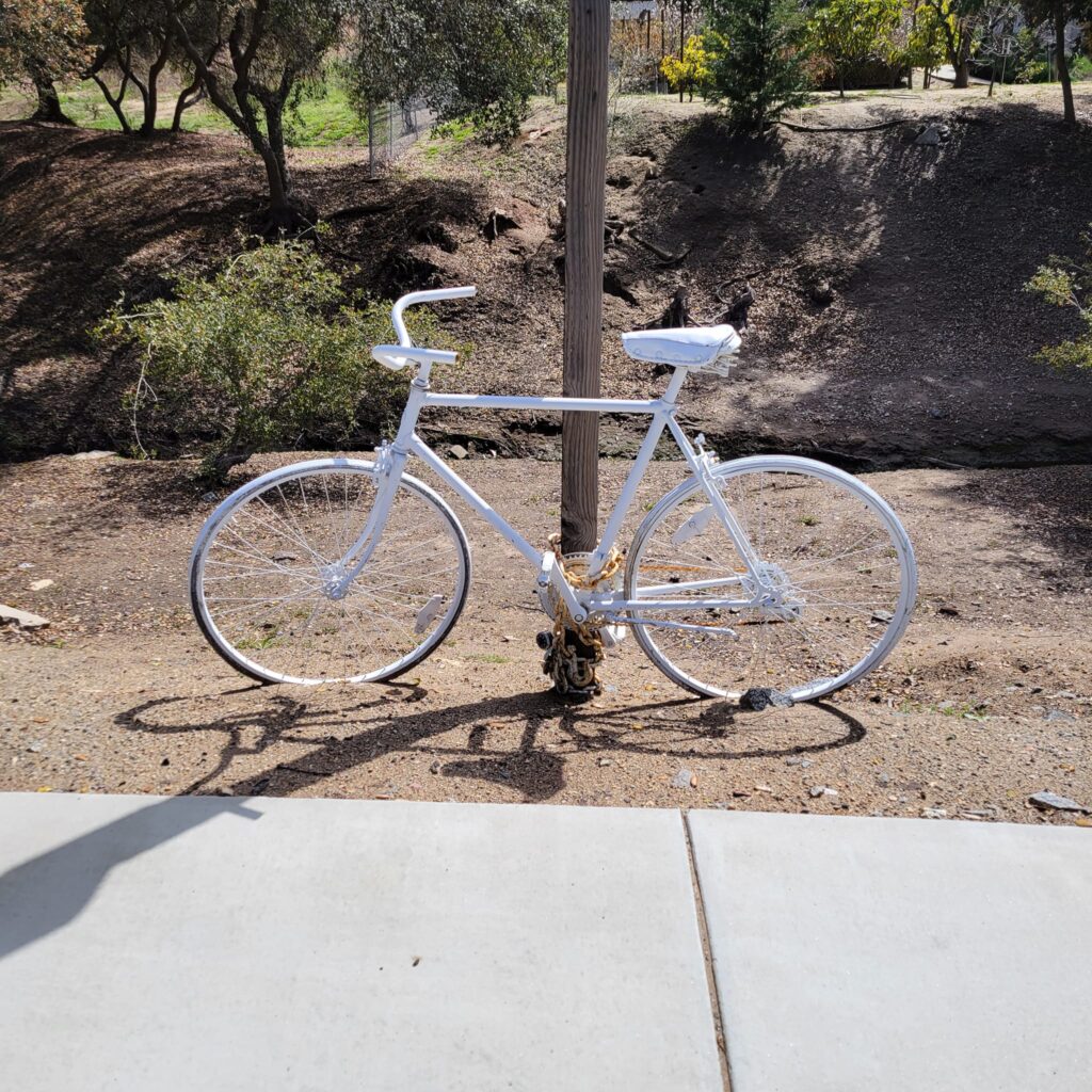
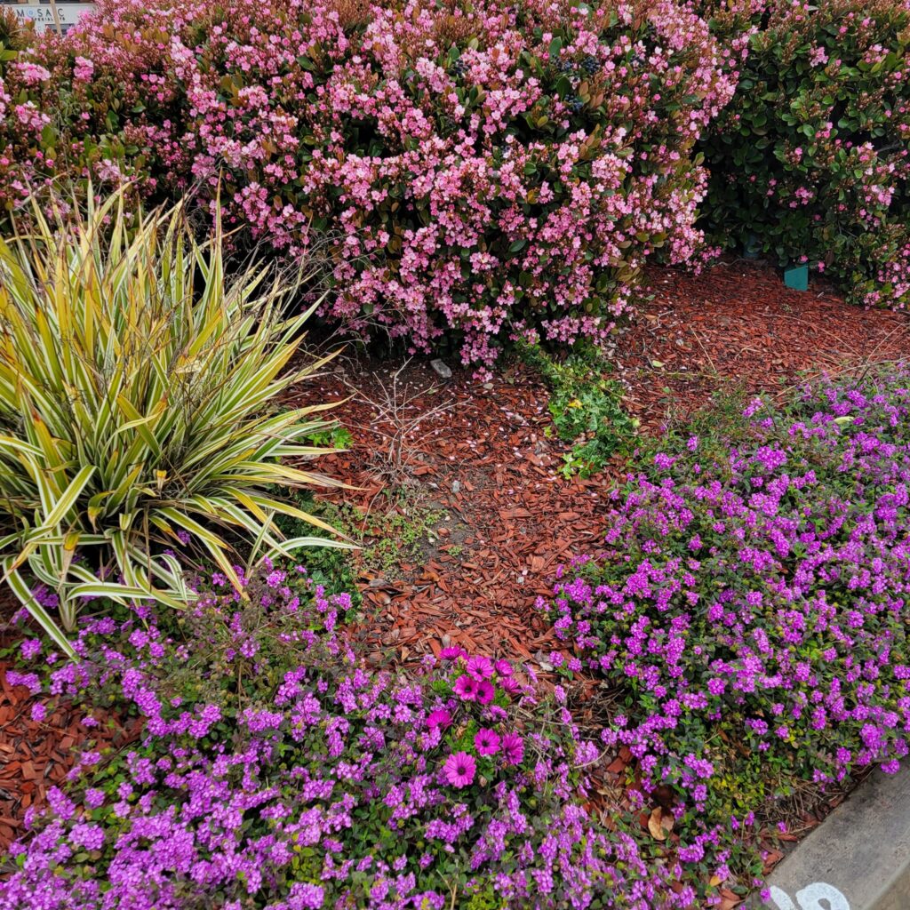
Later that day I inch my leaden bicycle into the tidy, well-kept community of Alpine. Many of the residences I encounter that day, including those in Alpine, have the most spectacular flower gardens. This seems like almost the perfect climate for flowers here in southern California. I am a little jealous as we have only a few months during the year back home in Wisconsin when the climate is suitable for gardening. As I ride into Alpine itself, I ride past a bicycle painted entirely white and chained to a signpost. This is known as a “ghost bike” and it signifies that a cyclist lost his or her life in an accident at this very spot. It’s a sobering reminder that a cyclist must always be alert, cautious, and ride defensively whenever riding in traffic.
Since I’m also trying to adhere to a whole-food, plant-based diet for the duration of my journey, a Subway restaurant alongside the road in Alpine is the perfect place to stop for lunch. At almost any Subway you can put together a veggie sandwich loaded with greens, tomatoes, green peppers, onions, and perhaps even avocado. After chowing down on my veggie lunch, I head back out on my bike to my hotel for the night.
I have reservations at the Viejas Casino and Resort, an Indian gaming casino. It is actually much more than what I really wanted to spend for a hotel on this trip but it seems to be the only option available for me this particular night. The resort grounds are much larger than I had anticipated. I get turned around and confused, but after asking a couple of attendants on duty, I finally find my way to my hotel. The staff there is exceptionally warm and welcoming. One of the attendants inside notices my bicycle and attire and brings me a large bottle of water. That is much appreciated!
It is a Friday afternoon and the resort and casino, being an hour’s drive away from San Diego, is becoming quite busy. There is a long line of people waiting to be checked into the hotel and as I am looking around and taking in my surroundings it occurs to me that something doesn’t really fit in here – and it’s me! And it isn’t just the loaded bicycle, bicycle shorts, helmet and jersey. I am indeed one of the very few slender people waiting in the hotel lobby.
I couldn’t help but to think how we as a society and a nation got to this place where nearly 42% of adults are considered obese and another 31% are overweight. As a kid growing up in the 1960s and 1970s (I was 65-years old at the time of my adventure) I remember obesity as something that wasn’t very common at all. In the 1960s and 1970s the obesity rate hovered around 13% to 14% and remained fairly stable during those two decades. In the later decade of the twentieth century and into the twenty-first century, obesity rates have skyrocketed. It seems that too many times obese people are blamed for their own obesity. They are blamed because of a lack of discipline, a lack of willpower, or just plain laziness as the cause of their plight. But is it possible for an entire society or country to lose discipline, willpower, and become overly lazy in just a couple of decades? It just doesn’t make any sense. One thing I do know is that food is available now in places it never was when I was a kid growing up. The gas station, the hardware store, places like this never had food; but now just standing in the check-out line there is a wide array of sugary, calorie laden treats. I’m not a nutritionist by any means, but I feel as though I know enough to realize that, unfortunately, obesity carries an enormous health burden, not just as a society, but for individuals as well.
Anyway, enough with the rant, I check into my room, which as expected is luxurious. I shower, nap a little bit, then head out to explore the resort grounds and find something to eat for dinner. The grounds are expansive and in addition to the enormous casino there are a variety of shops and restaurants as well. I find an Asian restaurant that has vegan items on the menu and order a vegetable tofu dish to go. I eat dinner in my room, watch a little bit of a movie on TV (I believe it may have been The Shawshank Redemption) and it’s off to bed. No all-night gambling for me! Day two on the Southern Tier: 24 miles (38.6k) ridden with 2,730 feet (832m) of climbing.
Day 3 overall on the Southern Tier – Day 3 of actual riding – Saturday, March 25th, 2023 – Alpine, CA to Pine Valley, CA
I’m up early, hungry and ready for breakfast. The casino is almost deserted in the early morning hours. And of course, to get to the restaurants from the hotel requires a walk through the casino. I find a café that has oatmeal and fruit. Perfect! But they won’t be open for another half-hour. I guess gamblers aren’t early risers. So I walk the grounds for a little while, come back to the café, down my breakfast, and head back to my room to pack-up and prepare for the day’s ride. It’s a sunny but cool morning and today’s ride will actually take me off the Southern Tier Route and onto a dirt road for a time. This is actually a detour that I put together weeks earlier. The actual Southern Tier Route goes on Interstate-8 for several miles but because of construction, cyclists are being asked to call for a shuttle service to transport them and their gear through the construction area. Instead, I devised a route around the construction that avoids the use of the shuttle service. My detour does, however, utilize a dirt road, which is probably why the Adventure Cycling Association never considered it in a route update. Nonetheless, my Trek Checkpoint SL-6 is technically considered a “gravel” bike; so why not?
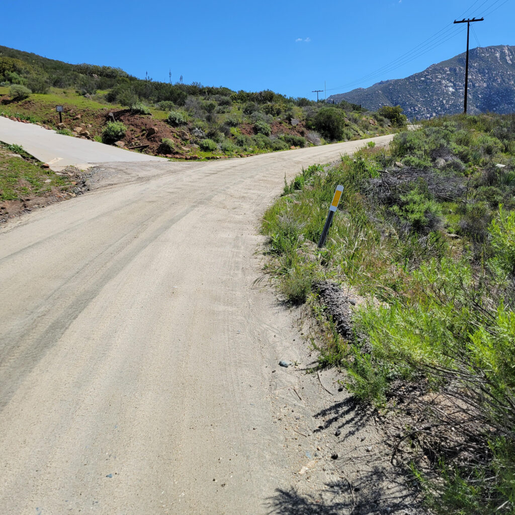
I head away from the resort, miss my turnoff, consult my smartphone and Garmin device, and get properly situated back on my renegade, improvised route and toward the gravel road. After a few miles on pavement, I turn onto dirt and promptly start climbing. The grade of the road varies between 5 to 7 percent and is proving to be a relentless, steady climb. But the road surface itself is actually in good condition. The dirt is hard packed and fairly smooth with little erosion. Nor is there any of the dreaded “wash boarding” frequently encountered on dirt roads, and there are very few potholes. I get into a steady rhythm and slowly make my way up into the hills. It proves to be a challenge but the climb is not as daunting as I feared. “I can handle this; I can do this!” becomes my mantra all the way to the top. I had worried so much for so many weeks about this particular climb but now it was behind me, and although it was indeed a challenging climb, it really didn’t seem all that bad. So many times, in life we worry and stew about potential problems in the future and they often turn out to be minor or insignificant. In the end, I actually enjoyed this climb as the scenery and the experience were spectacular.
Near Disaster!
The descent is relatively short compared to the ascent, as it always is. I soon come to a crossroads at the bottom of the hill. At a quaint little grocery named Veronica’s Kitchen and General Store I gather some items for an quick impromptu lunch. Then out of nowhere: disaster! As I reach for my backpack and my cash and credit cards to pay for lunch, I suddenly realize that I have left my backpack up at the top of the hill. As I was preparing for the descent down the other side, I had taken my backpack off to retrieve my jacket and left the backpack, with all my cash, credit cards, and identification, lying in the dirt. So, I race back out the store and frantically climb back up the hill hoping to still find my backpack, and its critical contents, exactly where I had left it. My mind is racing as I ascend. What if my backpack isn’t there? What will I do? I was fearful that a stupid mistake would mean the end of a transcontinental adventure that had just barely begun. Fortunately, the backpack and its contents lay undisturbed; right where I had left it. The lesson I learned that day: if I remove that backpack, either hang it from or lean it up against the bike so that I can never forget it again.
Disaster averted! Now it is a relaxed ride back down the hill to the general store and lunch. There is still more climbing after lunch but nothing as arduous as earlier in the day. I hook back up with the actual Southern Tier Route once again for a short ride to my motel for the night, The Pine Valley Inn Motel. This motel was the first of many “mom and pop” type establishments that are privately owned. All of them were very clean and tidy, although a few were run down, nearly all were very nice and much less expensive than a chain or franchise.
As I am chatting with the owner while checking in, I learn that I am catching a break in the weather. Several days earlier a couple cycling the Southern Tier had been camping out nearby, but wet and cold conditions had forced them to check into her motel. “They were cold, wet, miserable and had had enough!” she exclaimed. For me, it had actually been a gorgeous, pleasantly cool day.
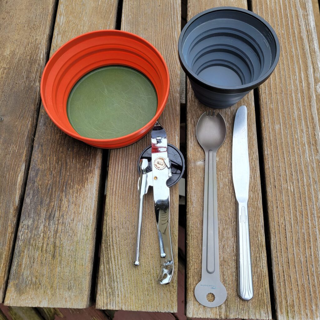
After checking into the motel and unpacking my gear, I head out for dinner. The local restaurants really don’t offer any kind of options for someone like me trying their best to adhere to a whole-food, plant-based diet. So, I head over to the local grocery store and find some oranges, a bag of greens, some berries for breakfast, and a can of beans. I also carry at all times in my bags some oatmeal, and a bag of spices. My “kitchen” consists of a titanium “spork”, a butter knife, a can opener, and a collapsible bowl and mug. I also always look for motels/hotels that have a mini-fridge and a microwave oven. I return to my room, eat dinner and promptly fall asleep. Compared to the distances compiled by some other riders, I’m slowly creeping along, but I am making progress. Day three on the Southern Tier: a little over 20 miles (32k) ridden with another 2,700 feet (823m) of climbing.
Day 4 overall on the Southern Tier – Day 4 of actual riding – Sunday, March 26th, 2023 – Pine Valley, CA to Boulevard, CA
Right out of the gate, upon leaving the motel, the day starts off with a fairly steep climb; that just seems to be the norm on this stretch of the route. There’s nothing like a little extra exertion at the beginning of the day to get things going. I make it to the top and while I was taking a break, I encounter a turkey hunter out enjoying the splendid weather. From what I could tell his hunt was unsuccessful but he didn’t seem to mind. He thoroughly enjoyed his walk in the wilderness and we chat for several minutes. He wishes me luck on my journey and we part ways. I always enjoyed chance encounters like this, and looking back, I wish there had been more of them. Maybe on my next tour I’ll take the initiative and just introduce myself to more people.
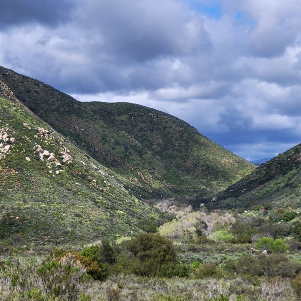
I am now in what I consider to be the “high country” east of San Diego. The terrain is more rolling for the next several miles but there are no more monster climbs today that will savage my legs. The scenery mainly consists of rugged, rock strewn hills and rock outcroppings. It is actually fascinating and beautiful. I stop often to take photos. Later in the morning I cross the Pacific Crest Trail, a 2,650-mile (4,265k) hiking trail that stretches from the Mexican border to the Canadian border traversing the states of California, Oregon and Washington. I stop to take more photos and notice a man, likely in his 30s, with a heavy backpack. He introduces himself and confirms my suspicion that he is indeed thru hiking the entire trail from Mexico to Canada. We chat for several minutes and wish each other a successful conclusion to our individual adventures. The bond between two kindred spirits felt especially strong for those fleeting moments.
Around midday I stop to take a break close to what appears to be a U.S. Border Patrol station. Anytime I would be riding within a few miles of the U.S.-Mexican border, which was a lot during this journey, I would almost always see several Border Patrol agents driving down the road. Their presence actually made me feel more secure. I felt that if I had any issues, a medical emergency, or equipment failure, I could always flag down a Border Patrol agent for help. By late afternoon I am approaching my destination for the day: a small motel just off the main route. But before the turnoff to the motel, I ride past a little rag-tag grocery and general store, the Mountain Top Market. I stop there and purchase my dinner for the evening: tortillas and a can of beans. I pedal on to my motel, The Back Country Inn, which is about a mile off the route and close to Interstate-8. The owner is a gregarious and welcoming older gentleman who makes me feel right at home. In the motel office are a variety of drinks and snack items for sale. I purchase a bottle of water, Gator Aide, and a bag of Frito Lay corn chips.
Corn chips became an item that I developed a craving for during my tour across the United States. I would search for a bag of corn chips at the end of each day. It seemed odd because I never eat corn chips at home; in fact, it’s something that, now that I’m at home, just seems downright disgusting. And it wasn’t anything like an addiction or obsession, I would only eat a couple of small handfuls of chips, and then I was done. I would roll up the remaining contents of the bag and save it for the next day. A few weeks later I would be staying at the home of a paramedic. He explained my craving for corn chips as my body’s way of saying that I needed to keep up on my consumption of salt to compensate for what I was perspiring out several hours each day. It made sense to me; especially so since I have been prone to cramping after a hard exertion.
The motel owner and I fumble around with the TV to finally get it working properly, and then I settle into my room, eat dinner, and go out for a brief walk right around sunset. The foreboding climbs east of San Diego that I had spent several weeks prior worrying about, were now largely behind me. Tomorrow’s riding will be mainly a steady descent into the Imperial Valley and the deserts of California. I changed into my PJs, tuck myself into bed, and quickly fall asleep. I am one more day closer to St. Augustine, FL. But that is still a long, long, long way away! Day four on the Southern Tier: around 22 (35k) miles ridden with another 2,140 feet (652m) of climbing, and 1,900 feet (579m) of descent.
Day 5 overall on the Southern Tier – Day 5 of actual riding – Monday, March 27th, 2023 – Boulevard, CA to Calexico, CA
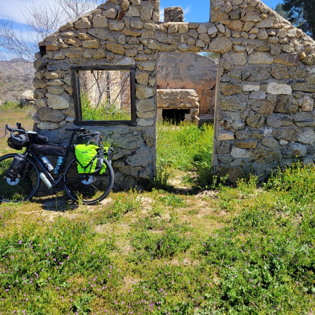
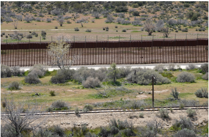
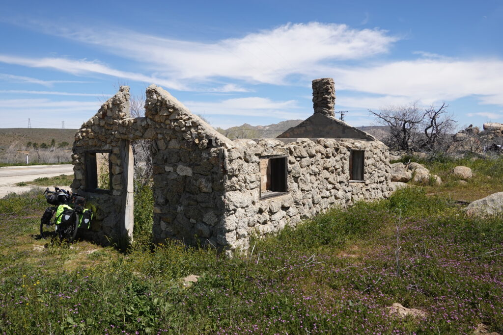
I am up earlier today, have my usual oats and berries for breakfast, pack up my bike, and fasten my seat belt because I know today was going to be a wild ride. But, the first several miles are similar to yesterday’s riding in the “high country”. The rugged rock-strewn hills and rock outcroppings dominate the landscape. I am fascinated by the presence of a couple of deserted buildings and stop to take pictures. I will soon discover that throughout this expanse of the Southwest deserted buildings are a common sight. I am always curious about these structures and often pondered their history. Perhaps their previous owners were fascinated with the remote expanse of this wild landscape, as I am, and relocated here thinking they could somehow make a living in this wild and desolate land. Inevitably, they had to give up on their dream and return to their previous way of life. I don’t know if that’s what really happened, but I often wondered about the particular circumstances and history whenever I came across a deserted building. Later that morning the route comes within a stone’s throw of the Mexican border. And I do mean that literally, if I had a good throwing arm, I could have lobed a baseball into Mexico. My cell phone even sends me a notification welcoming me to Mexico with instructions on how to retain cell phone service. At this location, the border is marked by an intimidating fence that likely towers 15 to 20 feet (4.5m to 6.1m). It is topped with barbed wire and instead of being solid it is comprised of slats that are spaced a few inches apart and are easy to see through to the other side. While I stood there staring at the border, I glanced to my right and spot another touring cyclist pulling up next to me.
He introduces himself, Philip, a Canadian also cycling eastbound on the Southern Tier. We chat for several minutes while I continue to take pictures of the border and surrounding area. We are still up in the “high country” and both comment on the beauty of the surrounding area and the how intrusive this border seems. And although my memory of that moment has waned and I don’t remember how, but we decided to both continue on our own. But fate somehow ensured that we would meet again.
After several more miles the route heads back onto Interstate-8 for the long, wild descent into the desert and the Imperial Valley of California. Unlike most parts of the United States where bicycle travel is prohibited on interstate highways, in certain parts of the West it is legal for cyclists to travel on interstate highways. This is due to the lack of roads in areas that are especially desolate and remote and it is often the only way to cycle from point A to point B.
After a few miles riding on Interstate-8, I encounter a large and imposing sign announcing the descent: “6% grade for the next 6 miles – trucks use low gear” (6 miles is 9.7k). I, of course, ride on the shoulder which is quite wide, around 12 feet (3.7m), and there is even a substantial rumble strip between me and the traffic lanes, so I feel safe. But the steady roar of traffic and large semi-tractors is almost deafening at times. I swear I’ve lost some hearing in my left ear because of that. Also, there is often a lot of garbage and trash strewn along the shoulders of highways. Everything from broken glass and nails to shredded steel radial tires. All of which can cause a puncture and flat tire. A cyclist has to be extra cautious and vigilant at all times.
The descent is actually not as easy as I was expecting. You just can’t let a fully loaded touring bicycle barrel down a 6 percent grade unchecked. To do so is a recipe for certain disaster. In addition, I am still getting use to handling the heavy-laden bike and in a steep descent like this the front wheel will start to wobble and shimmy as I pick up speed. So to compensate, I will often feather the brakes to control my speed and stop the wobble from becoming uncontrollable. However, I find that my hands and arms begin to tire and even begin to cramp. So even going downhill, frequent breaks become a necessity.
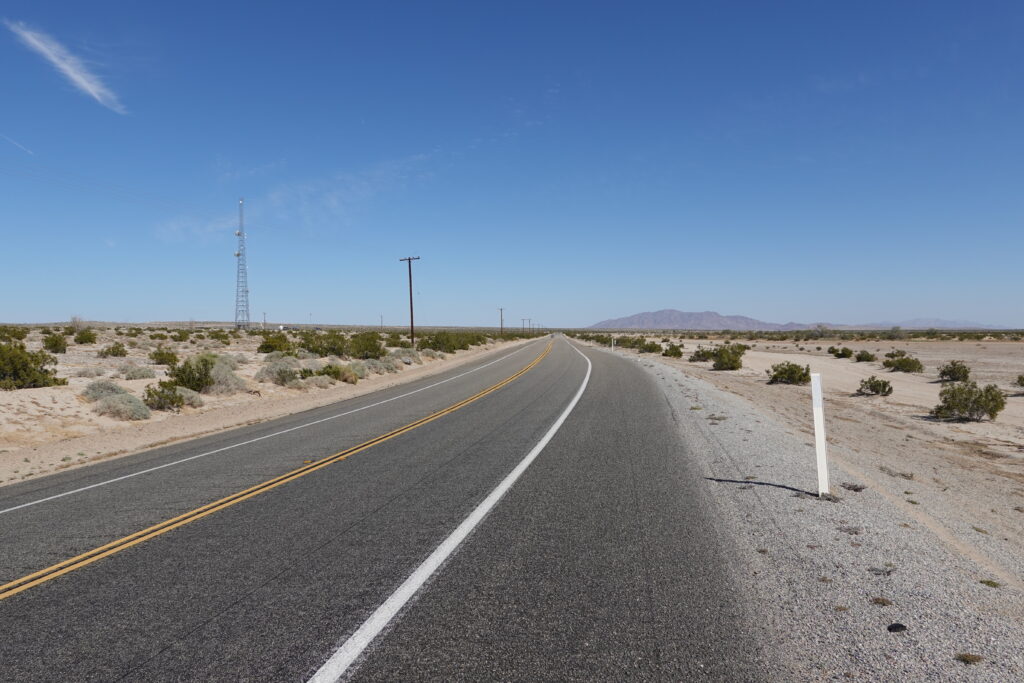
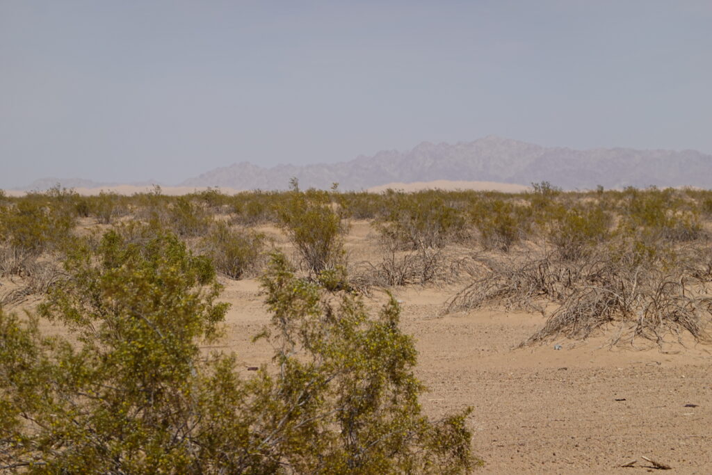
Eventually, the descent flattens out and I am in a completely different landscape. Gone are the rugged hills and the occasional pine forest, what lay ahead is a vast plain of sand, rock, and scrub brush. The temperature has warmed considerably as well. Mornings up in the “high country” were quite cool and on at least one morning there was a significant layer of frost on the ground. High temps during the day were generally pleasantly cool, in the 60s (15C to 20C). Now temperatures are around 80 (26.7C). After the descent, the route veers off Interstate-8 and onto California State Highway 98 and into Calexico where I have reservations at the John Jay Hotel for the night. But that is still over 30 miles away through a mostly barren landscape without services or water. However, Google Maps is showing a gas station and convenience store just a mile or so off the main route just up ahead. A refueling stop is a must. For the next several weeks, my route and daily mileage will be carefully planned with the significant distances between services always in mind. Running out of food and water in this vast, remote land where services can be and often are few and far between, is not even an option to consider.
After my pit and refueling stop I head back out on the main route and pedal toward Calexico. After several miles a car slows and pulls alongside me. They inquire about my final destination and seem to be aware of the Southern Tier Route that I am traveling. They ask me if I need anything. I reply that I am in good shape and they wish me a safe and fulfilling journey. That encounter really bolsters my spirits and carries me through for the rest of the day.
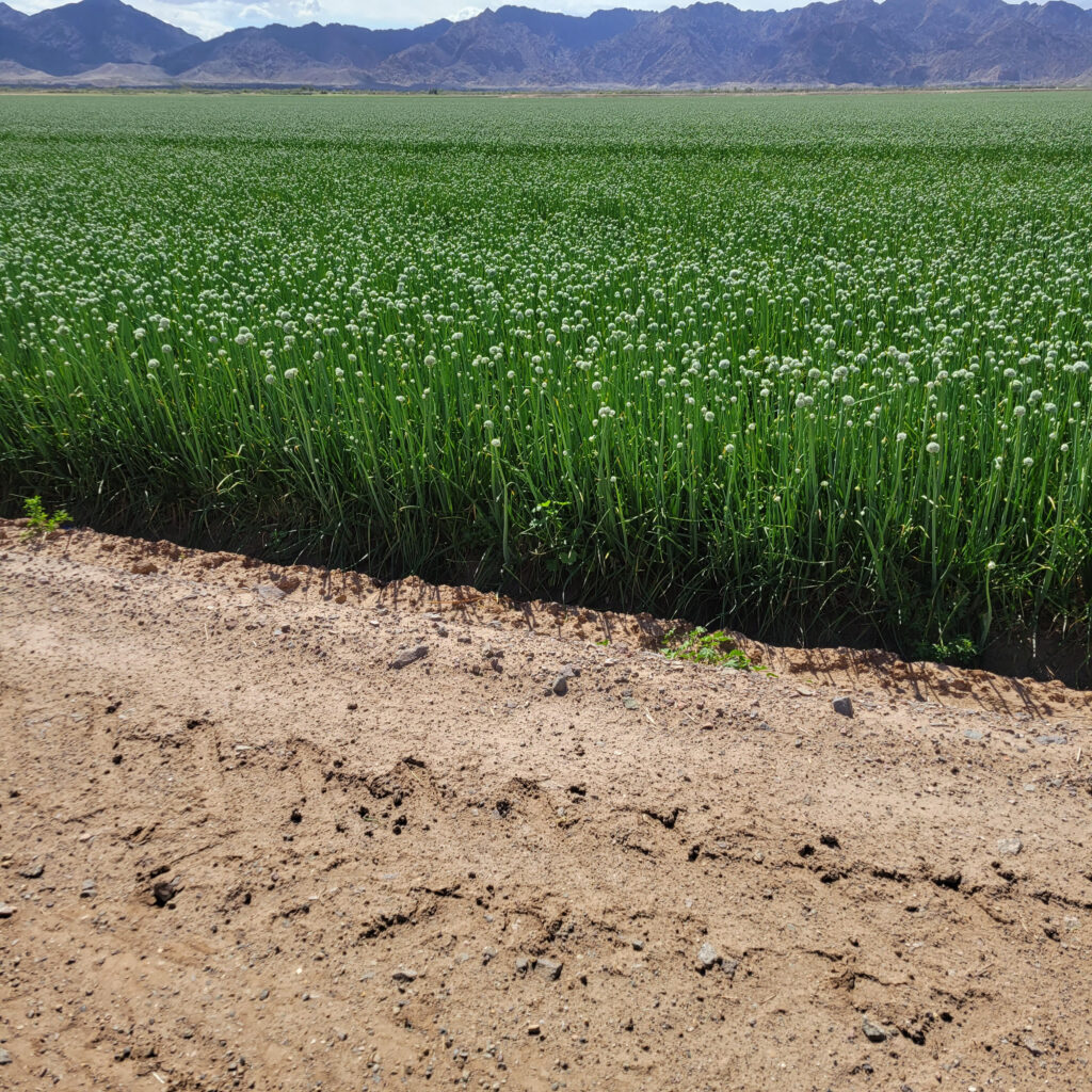
As I get closer to Calexico, I start to notice more irrigated fields and agriculture. In fact, in a few places fields of green now predominate, a welcome contrast to the barren desert. I now realize that this is probably where many of our vegetables are likely grown. Closer to Calexico traffic increases and construction makes for difficult navigation through the city. After the route turns north, I find a side road that has little traffic, as the main route is reduced to two lanes of traffic and no shoulder. I spot my hotel, the John Jay Best Western Inn, in the distance and somehow find my way through the maze of construction and congestion to check-in and get settled. After dinner and a short walk, I slip into bed for a long-awaited rest. Tomorrow will be a day off for me. Day five on the Southern Tier: around 58 (93k) miles ridden with only 970 feet (296m) of climbing, and a whopping 4,500 feet (1,372m) of descent. I find it interesting that I started the day well above 4,000 feet (1,219m) of elevation but at times, after my descent into the Imperial Valley, I was actually below sea level.
Day 6 overall on the Southern Tier – Rest Day number 1 – Tuesday, March 28th, 2023 – Calexico, CA
Calexico is a city with a population of about 40,000 residents that sits right on the border with Mexico. From what I could tell during my brief stay there Spanish is the language most often spoken but it seems that many of its citizens are also bilingual and speak perfect English with an American accent. The vast majority of its residents, almost 98 percent, are of Hispanic origin.
Although it is considered a rest day, it is really only a rest day because I will not be cycling today. I did sleep in past the time I would be usually rising. But there are several chores I need to do and I also want to be done early in order to have a restful evening and retire to bed at an early hour. First up is laundry, then there are some emails and social media posts to attend to, next is planning my route and where I will stay overnight for the next few days, after that is the chore of servicing my bike, then some stretching and light exercise in order to stay flexible and avoid cramps, and lastly a trip to a nearby Walmart to stock up on food. My excursion to Walmart feels like an immersion into a foreign culture. Everyone in the store, including all the employees, seems to be of Hispanic origin. Spanish is the predominant language spoken. The only English I hear is coming from me! When I go to check out the clerk is conversing with the family in line in front of me in Spanish. I am concerned that, for me, checking out is going to be awkward as I speak almost no Spanish. But when he finishes with them, he looks directly at me and says, “Welcome to Walmart!” His English is perfect, and his accent would fit in just about anywhere in the United States. Apparently, to work in customer service in Calexico one must be bilingual. And yes, I am the lone “gringo” at Walmart that day; the only one there of northern European heritage. On my way back to my hotel a stately looking woman, likely in her 70s, and carrying an umbrella to protect her from the sun, walks up next to me and tries to engage in conversation; in Spanish of course. I am dumbfounded and feel like an idiot. I mumble something incomprehensible and we both continue on our separate ways. Sometime, I hope to learn Spanish and actually engage in conversation with our Hispanic friends and neighbors.
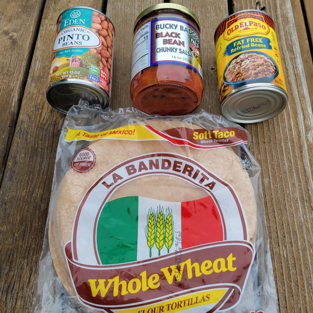
I return to my hotel, finish my chores, and prepare my Walmart dinner. What does dinner from Walmart look like? First off, the oranges anywhere in the grocery stores in California and Arizona are so delicious, juicy, and sweet that I always have to get at least a couple. Next up, a bag of greens, either spinach or mixed greens. I often peel the oranges and combine them in my collapsible bowl with the greens and just shovel it all into my mouth. Next up, a bag of frozen vegetables seasoned with some spices I always keep with me. Brussel sprouts and broccoli are my favorites but I often have mixed vegetables for some variety. Then a can of beans; pinto, black, and black-eyed peas were my favorites. I throw in spices, or a small can of seasoned tomatoes for flavor; and, of course, since I was traveling in the American Southwest, some whole wheat or corn tortillas. After eating all that, I was usually full. It is still early in the evening but I am ready to settle into bed. Tomorrow is going to be the longest ride yet and I want to get some sleep. Day six on the Southern Tier: rest day in Calexico.
Day 7 overall on the Southern Tier – Day 6 of actual riding – Wednesday, March 29th, 2023 – Calexico, CA to Yuma, AZ
Traffic is heavy this morning but the shoulders are wide and I have a slight tailwind. I cruise northbound away from Calexico at a steady clip. Several miles down the road the route for the Southern Tier splits. There is the more northern, traditional route that is probably more scenic and picturesque as it goes through the heart of the Imperial Sand Dunes. But the roads are winding, narrow, and hilly. In addition, the Adventure Cycling Association also indicates that the roads along this section are also, at times, heavily traveled and particularly hazardous for cyclists. It all sounds a little scary!
The southern option is the newer alternative, and is now the option advocated by the Adventure Cycling Association. It is perhaps less scenic but is considered far safer as the roads either have wide shoulders or are much less traveled. Several days before, I decided to heed the advice of the Adventure Cycling Association and take the southern route. After all, they are the experts in compiling these long-distance bicycle routes, so who am I to argue with their guidance. A right-hand turn and I am headed eastbound on the new alternative route.
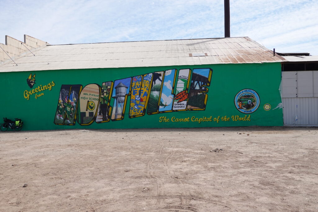
After several more miles I come to the town of Holtville, the self-proclaimed carrot capital of the world. Sprawling, massive cultivated fields with broccoli, onions, and I guess carrots as well, are now a common site. I also occasionally encounter groves of date palms. Irrigation pumps and irrigation channels seem ubiquitous along this stretch. The fields stand out in stark contrast to the sands of the vast desert that surround them. I stop at the Dollar General store in Holtville to grab a quick snack and continue on my way. I have several more miles before I get to my final destination for the day. A few miles after departing Holtville, the route parallels Interstate-8 on a side road for a fairly long stretch. Although the road is a little rough, it is nearly deserted and I feel as though I have it all to myself. But soon enough, the road ends and I am back riding on the shoulder of Interstate-8. The route passes through the southern end of what can be considered the Imperial Sand Dunes. Sand dunes of perhaps 15 to 20 feet high line either side of the interstate in some places. But off in the distance, I can see even higher, towering dunes that are impressive even from miles away. This is probably where the northern, more traditional Southern Tier Route traverses; the section that I chose to avoid. I can’t help but to think that I am missing out on some great scenery and I am beginning to regret my decision to stay south. But I am now committed and there was no turning back.
The last several miles are mostly riding on the shoulder of Interstate-8. I feel safe enough as the shoulder is very wide and there is again a rumble strip separating me from the onslaught of traffic. But the noise of traffic and especially from large trucks is overwhelming and at times grates on my nerves. I again swear I am going to go deaf in my left ear. Finally, the route turns away from the interstate and onto quieter roads the last few miles into Yuma. I will be spending the night at the Historic Coronado Motor Motel in Yuma. Although I have crossed over the Colorado River and I am now in Arizona, somehow it just doesn’t feel like I am crossing over into a new state at all. The next morning, I will be crossing the state line again right back into California for much of the next day. Usually, crossing a state line is a milestone for a touring cyclist and is a marker of progress. Perhaps tomorrow when I cross over into Arizona for good, I’ll celebrate. But for tonight, I check into my motel, walk to a nearby grocery store to gather up something for dinner, and flop into bed. It has been a fairly long day. Day seven on the Southern Tier: 65 miles (105k) of mostly flat terrain.
Day 8 overall on the Southern Tier – Day 7 of actual riding – Thursday, March 30th, 2023 – Yuma, AZ to Wellton, AZ
Up early, the usual breakfast of cooked oats and fruit, and I’m back on the bike, crossing over the state line back into California. It seems as though I’m actually going backwards, crossing over into a state I just left the day before, but that’s just the way things are today. The route today will be almost entirely on quiet, rural backroads. This is a welcome change from the frantic traffic that I’ve experienced the last few days cycling on the shoulder of Interstate-8. The road starts out smooth and is actually a delight to cycle on, but soon enough it turns rough, and full of potholes. However, after several miles it is once again smooth and silky.
This is a common theme for the entire trip; alternating smooth and rough pavement. Whenever I am blessed with a smooth and unblemished road surface, I have to realize that it will not last and that soon enough it will give way to something far less than pristine. So, I will just relish every minute of this gift of heavenly pavement and realize that it won’t last. Likewise, whenever I find myself on a cratered, scarred road surface I will just sigh and tell myself that this too shall eventually pass, and it always does. I guess is some ways bicycle touring is an analogy for life. I originally had planned a stop at a place called “Imperial Date Gardens”. But when I arrive at the location it appears to be closed, no one is around, and there are only a couple of pick-up trucks parked in the parking lot. So I head back down the road and soon encounter “The Cloud Museum”. It seems like a quirky and eccentric collection of old cars and related antiques. However, I don’t stop. Perhaps I am anxious about getting in the miles that day, or maybe, I am still feeling so uncertain and unsure of myself early on in this adventure. But looking back at it now, I regret my decision not to stop, at least for a few minutes. I now promise myself that I will stop at more of these quirky little tourist spots on any future bicycle tours.
The miles pass by and soon enough I realize I am in Arizona to stay. I was fully expecting a “Welcome to Arizona” posting alongside the road, but I never see one. The only indication I have that I indeed have crossed over the state line is by consulting my navigation apps. Yep, I am definitely now in Arizona!
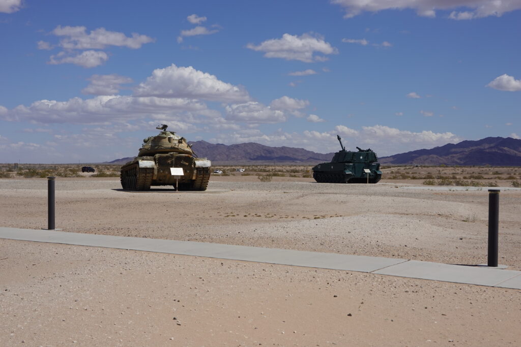
After several more miles I come upon the US Army Yuma Proving Grounds. The area is secured by a rather imposing chain link fence and barbed wire. And the mere size of the proving grounds impresses me as well. I cycle for perhaps over a half hour from one end to the other. A brief stop at the open-air museum there explains the reason behind the existence of the grounds. This was a space where new equipment and technology could be tested in the harsh conditions of a desert environment. It had to be proven to be reliable in these conditions before being pressed into service. The open-air museum contained an impressive display of old US Army vehicles, equipment, and arsenals. Apparently, they all passed the test and at one time or another were utilized by the US Army.
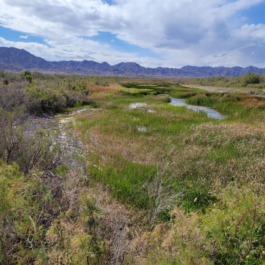
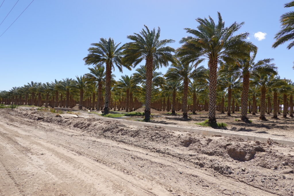
After leaving the Army proving grounds, the route crisscrosses through a varying and vast desert landscape. I also cycle past impressive large cultivated fields of all sorts of vegetables. The variety of the landscape never ceases to amaze me, agricultural fields, groves of date palms, and at one point at a river crossing I even encounter a marsh teaming with brush, grasses and wildflowers; definitely wasn’t expecting that!
I arrive at my destination for the night, the Microtel Inn & Suites in Wellton. While waiting to check into the hotel a couple of women saw me standing in line and inquire about my trip. They are astounded when I told them of my journey and intended final destination. However, I’m also still astounded whenever I consider my final destination. It still seems an impossible distance to navigate. But I have finally made it across at least one state.
Once checked in, I unpack, have dinner from what I could find at a Dollar General store up the street, and go for a walk in the fading light of dusk. I actually found Dollar General Stores to be quite accommodating to my whole-food, plant-based diet. I could almost always count on finding some type of frozen fruits and vegetables, a can of beans, tortillas, peanut butter, and a carton of non-dairy milk at these stores. Maybe it wasn’t the ideal but it was always filling and met my basic needs.
After my evening walk, I come back to the hotel and settle in for the night. Tomorrow night I will be camping out for the first time during my journey at a small RV park. I am actually a little nervous about how that is going to work out, but I’ll worry about it tomorrow. Right now, a good night’s sleep is what I need. Day eight on the Southern Tier: 52 miles (84k) of fairly flat terrain.